

Desert Mountain Club introduced an Iteractive Trail Guide that caters to both serious and novice hikers alike.
A new Interactive Trail Guide at Desert Mountain Club provides hikers and bikers with state-of-the-art data on everything from suggested routes to the best spots for viewing a sunset.
The Desert Mountain Club, a private golf and recreational community situated just north of Scottsdale, Ariz., boasts six Jack Nicklaus Signature Golf Courses. But it’s something off the fairways that’s attracting not only the attention of Desert Mountain members these days, but also other club managers looking for new ways to engage their own memberships and fully utilize their properties.
The property has installed a new Interactive Trail Guide that caters to both serious and novice hikers alike. Positioned at the trailhead of the property’s 15-mile private trail system, which encompasses seven separate trail segments, the guide allows hikers to select a route by distance, degree of difficulty, or even based on where they’ll come across the best sunset views.
Once the hike is selected, a customized map is created and can be scanned onto the hiker’s mobile device. Twenty of the most common routes, and accompanying GPS data, are pre-loaded into the system, to assist in selecting each person’s ideal hike.
Design by Demand
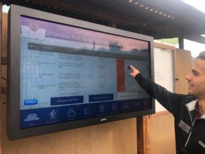
The Interactive Trail Guide allows Desert Mountain members and guests to fully customize hikes—from distance
covered to degree of difficulty.
Craig Mitchell, a member of Desert Mountain who designed the Interactive Trail Guide, says there was a strong desire within the community for such technology. Mitchell is also a member of the “Desperados” — a group of like-minded outdoor enthusiasts who are vigilant about advancing Desert Mountain’s outdoor recreation experience.
“Desert Mountain is a vibrant community, and the demands for all outdoor recreational opportunities [on the property] are growing rapidly,” Mitchell says. “About 66 percent of our golf members are hikers, and users [of the property] take 12,000 hikes per year. The Desperados wanted to provide consistent and accurate information to users in a fun, intuitive and engaging manner.”
While the technology behind the Interactive Trail Guide is not new, Mitchell says its application at Desert Mountain is a first-of-its-kind use. “The hardware and software solutions are readily available, but the trails application is an original design, unique to Desert Mountain,” he says. “This was our vision, and we were able to bring it to life.”
Mitchell says he felt like a “kid in a candy shop” when helping with the design of the Guide, which was compiled around user demands for information and the rugged Arizona environment.
“The Interactive Trail Guide was built based on questions from our members for data pertinent to our trails and their skills,” he says. “We wanted to take our trails experience to a new level, for beginner and advanced hikers and bikers alike.”
Full of Features

“As a premier golf and outdoor
recreation community, this type of technology and amenity is one the club industry is just now starting to explore, and we have fully embraced it.”
—Damon DiOrio, CCM, CCE
Chief Executive Officer,
Desert Mountain Club
In addition to providing mapped routes, the Interactive Trail Guide also has the capability to check current weather, view an informative species guide, scan interesting facts and recommend specific hikes. Photos submitted by members from recent trailhead events will also be on display, as well as information about the Desperados.
For those not technologically savvy or wanting to stick to tried-and-true methods, Mitchell says printed maps are readily available at the trailhead. That said, because the hiker can scan and download selected hikes to a smartphone, the Interactive Trail Guide provides mobile support with GPS coordination to assist along the way, which a traditional map can’t do.
Another plus is that members don’t need a dedicated app on their phone or device; instead, they can just “grab and go.”
“The software resides on a media player [hard drive] that is attached to the on-site monitor,” Mitchell says. “However, each map displayed on the Guide monitor has a QR [quick recognition] code that can be easily scanned and downloaded to a mobile device.”
To fund the Interactive Trail Guide, the Desperados—a 501(c)(3) organization operating under the umbrella of the Arizona Community Foundation—relied on member contributions.
“We do community-based work within and outside of Desert Mountain,” Mitchell says. “The original 15-mile trail system was built entirely on member donations.
“Our future plans,” he adds, “include local volunteer work, local philanthropy, new trails, a 60-foot mosaic representing the Sonoran Desert from sunrise to sunset, a ‘base camp’ map of outdoor activities available in a 100-mile radius of Desert Mountain, and of course, the Interactive Trail Guide.
“All of this has been and will be funded by member donations through Desperado Development Campaigns,” Mitchell continues. “We are also fortunate to receive support from Desert Mountain Club, the Desert Mountain Community [HOA], the Desert Mountain Community Foundation and Russ Lyon Realty.”
Plenty of Potential
While golf courses and resorts are generating revenue through new technology—such as ordering food and beverages from a golf cart or selling ads on the in-cart screen— Mitchell says the Desperados have no current plans for monetizing the Interactive Trail Guide. However, their application is copyrighted, and the group is looking into trademarks and licensing.
As for expanding the use of the Interactive Trail Guide beyond the trails, Mitchell says “The Desperados are always thinking of how to advance outdoor recreation at Desert Mountain—that is our mission. The Guide is new, but we always listen to our fellow outdoor enthusiasts, [and] that will drive our future features.”
Recognizing how the community is at the forefront of this movement, Desert Mountain’s Chief Executive Officer, Damon DiOrio, CCM, CCE, is eager to share this technology with golf courses and resorts nationwide.
“As a premier golf and outdoor recreation community, this type of technology and amenity is one the club industry is just now starting to explore, and we have fully embraced it,” DiOrio says. “[In early January], Desert Mountain will serve as host to 50 club managers from around the country, to showcase this and other outdoor amenities that are geared toward providing a variety of health and wellness opportunities for the golf enthusiast and their families.”
That event, DiOrio says, has grown out of recognition by the Club Management Association of America [CMAA] that “there has been an explosion in non-golf facilities around the country as one of the hottest [and most] sustained trends in the industry.
“Recognizing this, [the CMAA] came to the leadership of [its Southwest Chapter] for help, knowing that clubs like ours are among a group here at the cutting edge of these outdoor recreational pursuits,” DiOrio adds.
That led to the development of the week-long program, offered to club managers as part of the CMAA’s Certified Club Manager certification process, that was scheduled for the Scottsdale area for the week of January 7-11. The agenda included visits to Arizona Country Club and The Desert Highlands Country & Golf Club, in addition to Desert Mountain.
Seminar sessions covered a full variety of topics in addition to hiking and biking, including: youth programming; kids camps; winter sports; lawn games; fitness and wellness technology and nutrition; tennis and racquet sports; adaptive sports; yachting and sailing; bocce; croquet; aquatics; “glamping”; and “doorstop sports.” Presentations were made by managers from many other clubs throughout the country, in addition to the host clubs.
Expanding the Technology
While Desert Mountain doesn’t have any immediate plans to also utilize its new Interactive Trail technology on the golf course, DiOrio says a possible expansion is planned within the hiking realm. “We are looking into installing a duplicate version of the Interactive Trail Guide at the Sonoran Clubhouse, which serves as our hub for fitness, wellness and outdoor experiences,” he says. “This way, members can plan their hikes before hitting the trail.” C&RB


Tell Us What You Think!
You must be logged in to post a comment.